FOR IMMEDIATE RELEASE:
CONTACTS:
February 14, 2012
Andrew Stevenson, Co-President
Chuck
Preble, Vice-President
Peninsula Trails Coalition
Peninsula Trails Coalition
360-928-0276/360-461-4286 cell
360-683-4549/360-460-1220 cell
PTCPrez1@OlympicDiscoveryTrail.org
ChuckPreble@msn.com
Olympic Discovery Trail, vision in jeopardy
Recent notice,
impending deadline could create major problem for trail connection
 The
vision of the Olympic
Discovery Trail as a continuous recreational trail from Port Townsend
to the Pacific Ocean is threatened due to the short time span between a
Washington Department of Fish & Wildlife (WDFW) announcement last
fall and an existing spring schedule deadline for the state's estuary
restoration project along Discovery Bay.
The
WDFW decision to remove a trestle and lower the adjacent historic
railroad grade that trail proponents had hoped to use for the Olympic
Discovery Trail north of Highway 101 was announced just last fall as
part of the final planning stage for the state's estuary restoration
efforts on Discovery Bay. The Peninsula Trails Coalition (PTC) was
aware that most of rail grade had to be removed, but it was only as the
details and results of environmental studies and planning were
available that it became clear that removing a specific section that
included an existing short trestle along the west end of Discovery Bay
was necessary to meet restoration goals. This means a new route for the
trail closer to Highway 101 needs to be established, designed and
integrated into the state's estuary project and done within a very
limited time frame, to meet an already scheduled March 31st restoration
project deadline.
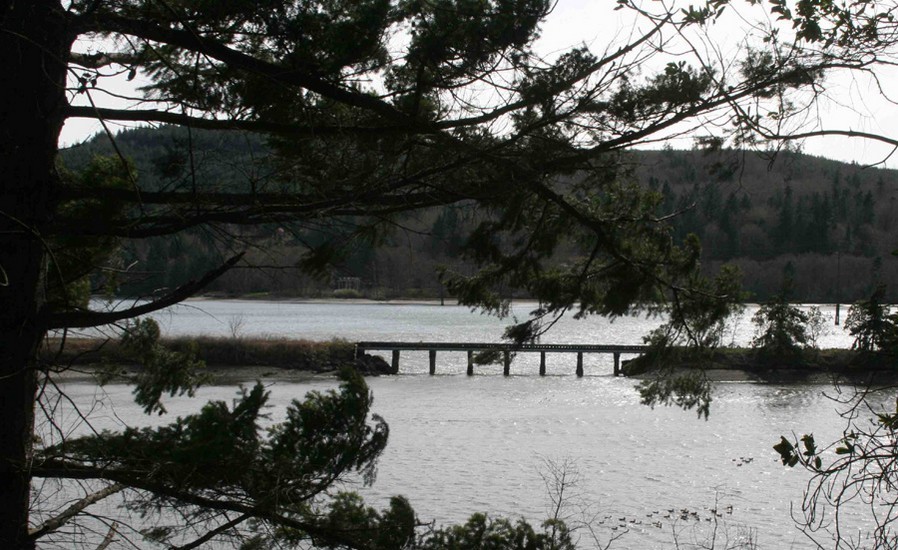
RIGHT: Discovery
Bay rail trestle to be removed / Image courtesy Peninsula Trails
Coalition
Although the Jefferson Trails
Coalition and their parent organization, the Peninsula Trails Coalition
(PTC), are working cooperatively with the North Olympic Salmon
Coalition, the entity overseeing the project on behalf of WDFW,
existing budget problems prevent Jefferson County from providing
personnel or funding at this critical time period. This means all
needed funding to complete the necessary design phase for trail and
restoration project integration must come from other sources.
The PTC has already committed $10,000
of their own existing funds to determine the feasibility of the route,
but the design phase portion is estimated to cost another $35,000, and
the group is actively pushing to reach that goal by March 31st.
 "The
design phase for the first
portion of this route, on the west side of the estuary, must be
completed this spring in order to meet restoration schedules and be
included in the permitting process," notes Andrew Stevenson, Peninsula
Trails Coalition Co-President. "If we miss this window of opportunity
then it will be practically impossible to obtain the required permits
and environmental mitigation credits later."
"The
design phase for the first
portion of this route, on the west side of the estuary, must be
completed this spring in order to meet restoration schedules and be
included in the permitting process," notes Andrew Stevenson, Peninsula
Trails Coalition Co-President. "If we miss this window of opportunity
then it will be practically impossible to obtain the required permits
and environmental mitigation credits later."
Also according to Stevenson, any
alternative route for the trail would require two hazardous crossings
of Highway 101, an easement through developed land, and permits through
the environmentally sensitive Salmon Creek area, again, for all
practical purposes, impossible.
"We have defined a cooperative
program to develop the trail design and integrate it into the larger
project, and working together with the North Olympic Salmon Coalition,
we have contracted with Parametrix, a Pacific Northwest company, to get
the job done," notes Stevenson. "But completing the design of the west
side trail section in concert with the rest of the restoration plan is
critical. We must either meet this schedule or give up the idea of
safely connecting the Port Townsend end of the trail with Sequim, Port
Angeles and other western portions of the Olympic Discovery Trail."
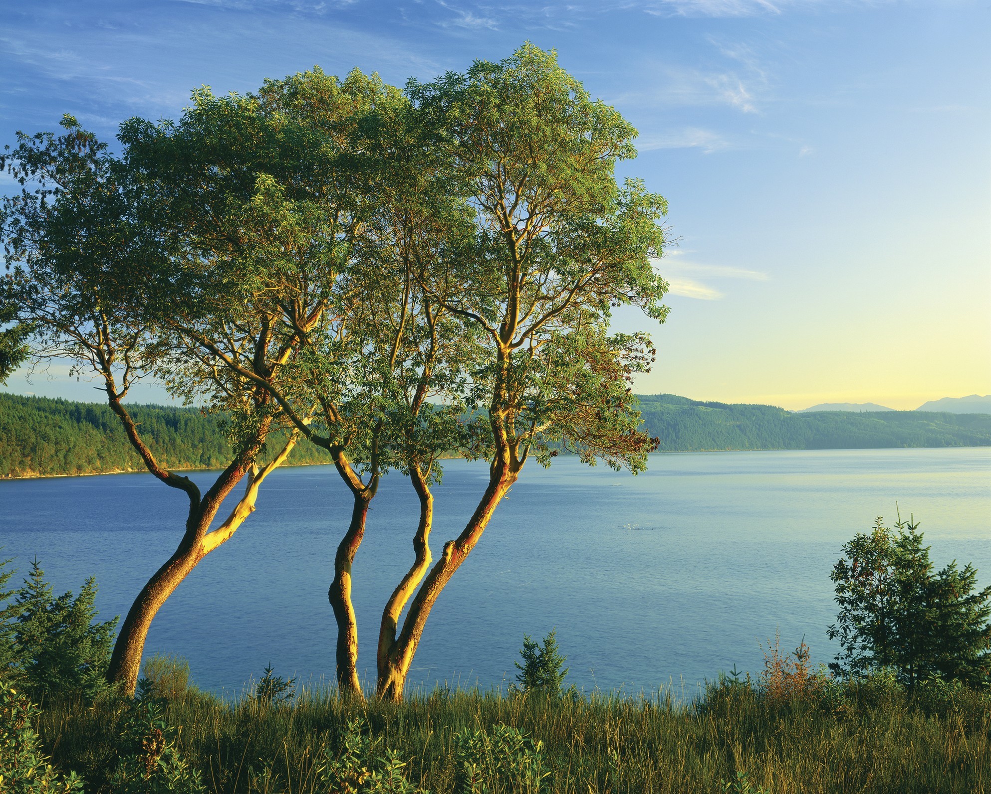
LEFT: Discovery
Bay with Madronas / Image courtesy of and © Ross Hamilton
Peninsula Trails Coalition board
members and leading trail supporters in the Jefferson Trails Coalition
pledged a $7,500 challenge match, and support from a recent special
fund-raising event and direct mail campaign recently met and exceeded
the match with $8,800. That's $16,300 of the needed $35,000,
close to half the total needed, but $18,700 still needs to be raised
over the next 6 weeks, an average of close to $400 per day by March
31st.
“We've been working on this trail for
over twenty years. Community support has gotten us a long way in
making the dream a reality, and community support, both locally and
statewide, is needed now more than ever to keep the dream alive,” added
Stevenson.
Contributions are tax-deductible and
may be donated either online at OlympicDiscoveryTrail.com or by check
to the “Peninsula Trails Coalition” and mailed to the organization at
PO Box 1836, Port Angeles, WA 98362.
 The
vision for the route of the Olympic Discovery Trail (ODT) is to travel
120 plus miles of lowlands, bordered on the south by the Olympic
Mountain Range and on the north by the Strait of Juan de Fuca. It
begins in the Victorian era seaport of Port Townsend connecting west
through Sequim and Port Angeles and will end on the shores of the
Pacific Ocean. Existing trail sections wind through fields and
farms, parks and towns; over creeks, rivers and ravines on restored
railroad trestles; and past beaches and national recreation
areas. The current paved pathway designed to accommodate
bicyclists, hikers, and disabled users includes a 4’ shoulder for
equestrians where appropriate, and offers a wide diversity of fauna and
flora and scenic beauty given the Olympic Peninsula is filled with
majestic views of snow capped peaks, ocean vistas, fast flowing rivers,
pristine lakes, and the temperate rain forests of the Pacific Northwest.
The
vision for the route of the Olympic Discovery Trail (ODT) is to travel
120 plus miles of lowlands, bordered on the south by the Olympic
Mountain Range and on the north by the Strait of Juan de Fuca. It
begins in the Victorian era seaport of Port Townsend connecting west
through Sequim and Port Angeles and will end on the shores of the
Pacific Ocean. Existing trail sections wind through fields and
farms, parks and towns; over creeks, rivers and ravines on restored
railroad trestles; and past beaches and national recreation
areas. The current paved pathway designed to accommodate
bicyclists, hikers, and disabled users includes a 4’ shoulder for
equestrians where appropriate, and offers a wide diversity of fauna and
flora and scenic beauty given the Olympic Peninsula is filled with
majestic views of snow capped peaks, ocean vistas, fast flowing rivers,
pristine lakes, and the temperate rain forests of the Pacific Northwest.
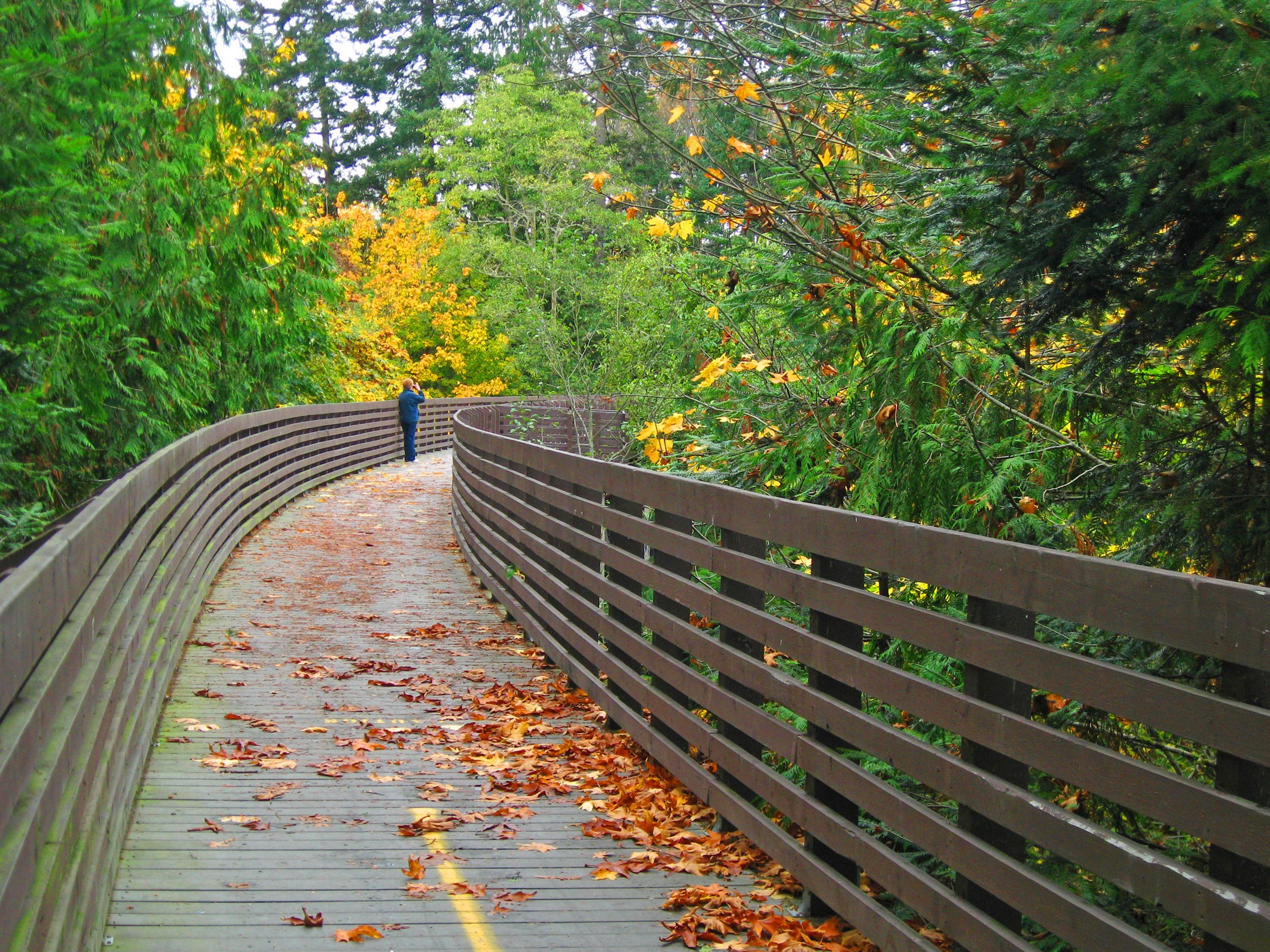
RIGHT: Olympic Discovery Trail
section in Port Townsend / Image courtesy of the Peninsula Trails
Coalition
# # # # #
The Peninsula
Trails Coalition is a non-profit organization and dedicated to
developing, protecting, maintaining and enhancing the envisioned
126-mile Olympic Discovery Trail from Port Townsend to LaPush, WA.
Existing trail sections provide recreational access for cyclists,
walkers, equestrians and people with disabilities. The
organization has helped develop over 40 miles of separate paved path,
placed tables and benches, and installed and maintained portable
restroom facilities. Completed sections are expected to total 53
miles during 2012, with right of way agreements in place for over 65
miles. The organization is managed by, and much of the trail work
is done by dedicated volunteers. For
more information and how you can support the trail visit the
organization's OlympicDiscoveryTrail.com website.
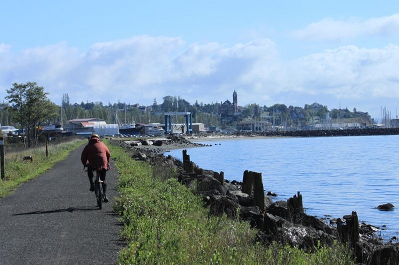
LEFT: Olympic
Discovery Trail section east of Sequim / Image courtesy and © by
Ross Hamilton
IMAGES WITH CAPTIONS ABOVE WITHIN THE
PRESS RELEASE
ARE AVAILABLE FOR FREE USE
WITH PERMISSION
GRANTED TO USE THEM RELATIVE TO THIS STORY BY THE PRINT MEDIA.
THEY MAY BE CROPPED, COLOR-BALANCED
AND DIGITALLY MODIFIED AS NEEDED.
Resolution for PTC
images is 200dpi, Ross Hamilton image is 300 dpi.
PLEASE
CREDIT THE SOURCE AS SPECFICALLY NOTED IN EACH IMAGE USED.
CONCEPT IMAGES BELOW ARE FOR
INFORMATIONAL PURPOSES ONLY,
SINCE THEY MAY BE SUBJECT TO
COPYRIGHT RESTRICTIONS . . .
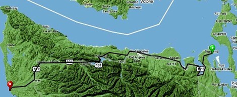 Olympic Discovery Trail General Route Concept:
NOTE: This image below provided
solely for informational purposes,
and its use elsewhere may
be subject to copyright restrictions.
- Port Townsend
- Discovery Bay
- Sequim
- Port Angeles
- Lake Crescent
- Forks
- LaPush
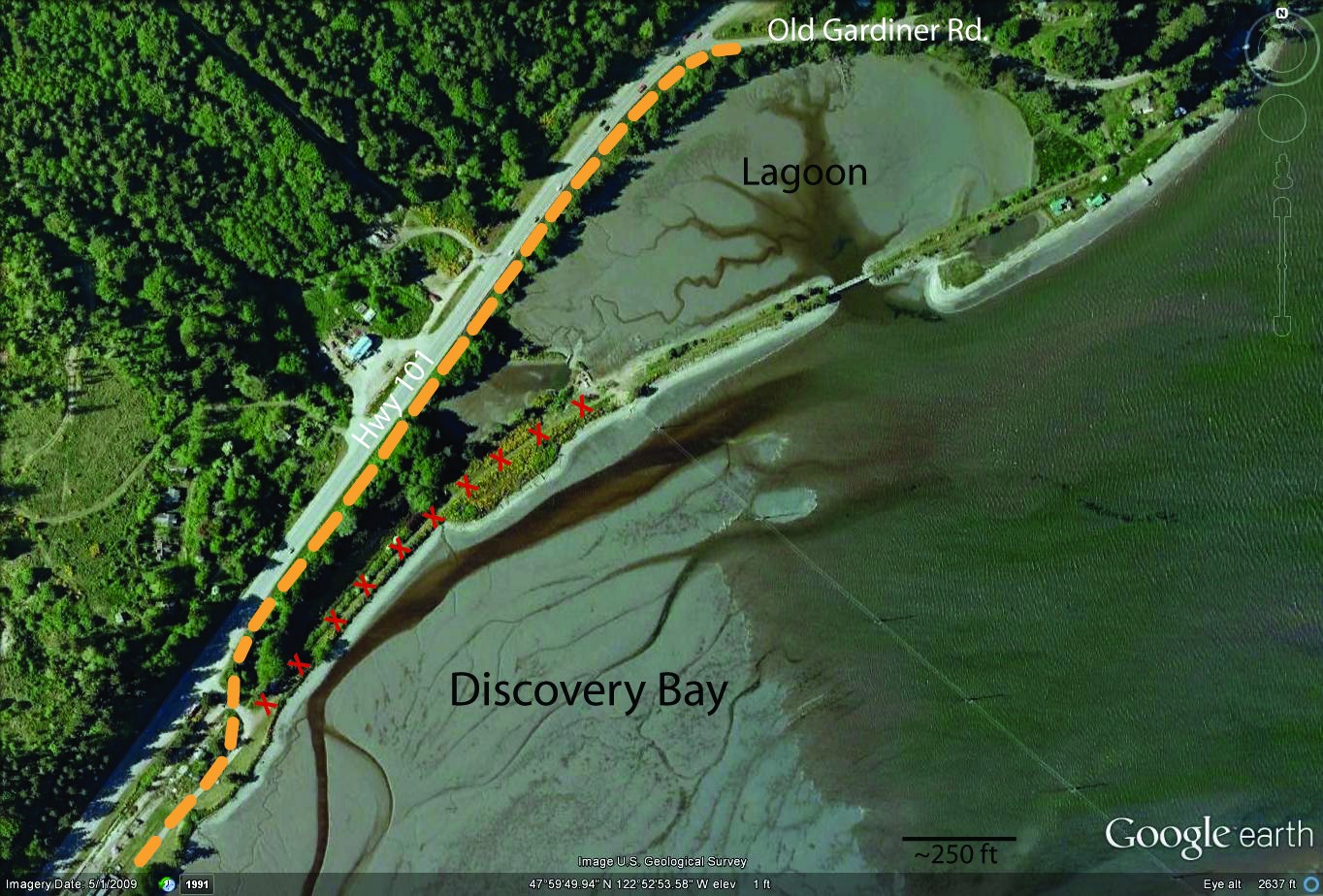
Concept
Map with Route Detail for the Discovery Bay section (below) as
referenced in the above release with picture of trestle to be
removed.
Yellow
line indicates trail reroute currently envisioned.
NOTE: This image below provided solely for
informational purposes, and its
use elsewhere may be subject to copyright restrictions.